We can now see the surface of Mars in astonishing detail thanks to a team of British researchers who used a revolutionary image stacking and matching technique. In their new set of photographs, we are able to see the location of Beagle 2, a British landing spacecraft that formed part of the European Space Agency’s Mars Express mission launched in 2003.
Scientists at University College London (UCL) in England say their images include the ancient lake-beds discovered by NASA’s Curiosity rover, the Beagle 2 lander, Home Plate’s rocks, and NASA’s MER-A rover tracks.
Resolution improved by a factor of five
Professor Jan-Peter Muller from the UCL Mullard Space Science Laboratory, and colleagues explained in the journal Planetary and Space Science (citation below) that the resolution of their images is up to five times greater than anything that anybody had previously achieved.
 Using a stacking and matching technique known as Super-Resolution Restoration, scientists can now produce images in unprecedented detail. (Image: ucl.ac.uk)
Their revolutionary technique, known as SRR (Super-Resolution Restoration), has only recently been used to focus on specific targets on Mars.
The technique could be utilized to search for other artefacts including landings, as well as pinpointing safe landing locations for future rover missions. It will also allow researchers to explore considerably more terrain than is possible with just a single rover.
Objects seen in much sharper focus
Prof. Muller said:
“We now have the equivalent of drone-eye vision anywhere on the surface of Mars where there are enough clear repeat pictures. It allows us to see objects in much sharper focus from orbit than ever before and the picture quality is comparable to that obtained from landers.”
“As more pictures are collected, we will see increasing evidence of the kind we have only seen from the three successful rover missions to date. This will be a game-changer and the start of a new era in planetary exploration.”
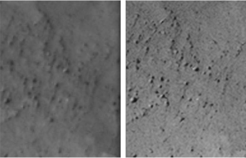 Comparison between (left) 25 cm HiRISE ORI image of an area of Mars’ surface and (right) 5 cm SRR image. (Image: sciencedirect.com)
Even with the most sophisticated telescopes that we send into orbit, the level of detail that can be observed on the surface of Mars and other planets is limited.
The authors say the limited detail is due to constraints on mass, mainly telescopic optics, the communication bandwidth required to deliver higher resolution images back to Earth, and the interference from planets’ atmospheres.
Resolution limit from 25cm to 5cm
For cameras that orbit Mars and Earth, the current resolution limit is about 25cm (10 inches).
By stacking and matching images of the same area captured from different angles, SRR allows objects just 5cm (1.96 inches) across to be seen from the same 25cm telescope.
For the Red Planet, where the surface typically takes decades to millions of years to change, these images can be captured over a period of ten years and still achieve a very high resolution.
Because of the atmosphere on our planet, images for each stack need to be obtained in a matter of seconds.
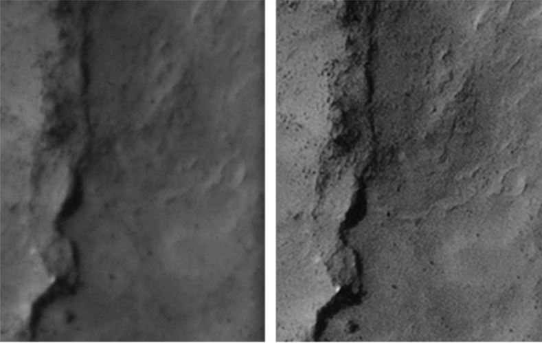 See the difference in the definition of the ridge, shadows, rocks and subtle surface formations between the 25 cm HiRISE image on the left and the 5 cm SRR image of an area of Mars’ surface. (Image: sciencedirect.com)
The UCL scientists applied SRR to stack from four to eight 25cm images of Mars’ surface taken using the NASA HiRISE camera to achieve the five-centimetre target resolution. These include some of HiRISE’s latest images of the Beagle 2 landing area that were kindly provided by Professor John Bridges, who works at the University of Leicester.
Lead author of the paper, Mr Yu Tao, a Research Associate at UCL, said:
“Using novel machine vision methods, information from lower resolution images can be extracted to estimate the best possible true scene. This technique has huge potential to improve our knowledge of a planet’s surface from multiple remotely sensed images. In the future, we will be able to recreate rover-scale images anywhere on the surface of Mars and other planets from repeat image stacks.”
The team’s ‘super-resolution’, zoomed-in photograph of the Beagle 2 location, proposed by Prof. Mark Sims and colleagues at the University of Leicester, provides compelling supporting evidence that this is the site of the lander.
 Mr. Yu Tao (left) and Prof. Jan-Peter Muller.
The authors say they plan to explore others areas on Mars’ surface using the technique to see what else they find.
In an Abstract in the journal, the authors wrote:
“We demonstrate optimality of this technique in planetary image super-resolution restoration with example processing of 8 repeat-pass 25 cm HiRISE images covering the MER-A Spirit rover traverse in Gusev crater to resolve a 5 cm resolution of the area.”
“We assess the “true” resolution of the 5 cm super-resolution restored images using contemporaneous rover Navcam imagery on the surface and an inter-comparison of landmarks in the two sets of imagery.”
Citation: “A novel method for surface exploration: Super-resolution restoration of Mars repeat-pass orbital imagery,” Y. Tao, , J.-P. Muller. Planetary and Space Science, Volume 121, February 2016, Pages 103–114 DOI: 10.1016/j.pss.2015.11.010.