A Boxing Day weather bomb warning has been issued in the United Kingdom, with the likelihood of more than 4 inches of snow falling in some areas, gale-force winds and blizzards.
Dubbed in this case as the “Boxing Day Bomb”, “rapid cyclogenesis”, also known as “explosive cyclogenesis” is the rapid formation of a depression, seemingly from nothing in an extremely short space of time. Typically it turns into a vicious storm within hours.
With millions of people travelling to and from friends and relatives, and bargain hunters taking to the streets, there is a serious risk of chaos on the roads.
The Meteorological Office (Met Office) says the turn in the weather will contrast with the unseasonably mild temperatures the country has enjoyed so far.
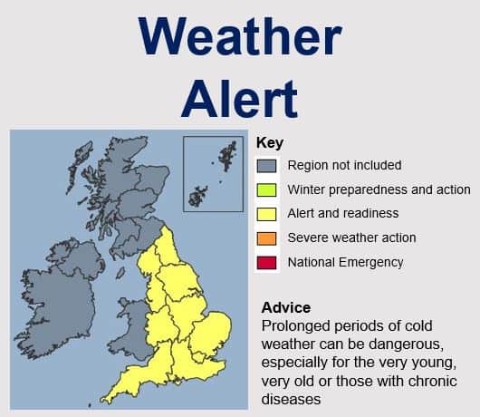
Source: “Current alert level: Level 2 – Alert and Readiness,” Met Office, UK.
In an official statement made on Christmas Day, the Met Office said:
“There is an 80% probability of severe cold weather/icy conditions/heavy snow between 1500 on Friday and 0000 on Wednesday in parts of England. This weather could increase the health risks to vulnerable patients and disrupt the delivery of services. Please refer to the national Cold Weather Plan and your Trust’s emergency plan for appropriate preventive action.”
Wet and windy weather is expected over the England on Boxing Day, the Met Office warned. Snow will probably fall in some northern and central areas of the country, with heavy drifting on hills.
The Met Office added that there is also an increasing likelihood of snow affecting some areas in the south of England. Areas currently at greatest risk of severe weather conditions are the southern parts of northern England and the Midlands.
On New Year’s Eve, temperatures could plummet to -6C (21.2F). Revellers have been advised to plan for abnormally severe weather conditions.