
Dunwich was England’s 10th largest town in the 11th century – most of it no longer exists thanks to a series of storms which pushed it under the sea and turned it into Britain’s equivalent of the lost city of Atlantis. Scientists have unearthed interesting evidence of the lost town and its origins.
The finds were unearthed off the coast of Dunwich in Suffolk, East Anglia, a small village 92 miles north-east of London – the village today is the part of the city that remained above sea level.
In the 13th and 14th centuries the town was hit by a series of devastating storms, which eventually pushed it to below sea level.
 This model shows what Dunwich probably looked like in the year 1200 – a prosperous, thriving coastal town in East Anglia. (Image: abandonedcommunities.co.uk)
Dunwich had been a prosperous coastal town during the early medieval period. Bishops had been based there, starting with Felix between 636 and 647 AD, and ending with Aethilwald in the middle of the 9th century. At that time it had a splendid natural harbour on the Suffolk coast.
According to data in the Domesday Book, Dunwich had an estimated population at the time of approximately 3,000 permanent residents, including 24 ‘Franci’, thought to be people of French origin who migrated to the British Isles after the Conquest.
Several major storms sealed Dunwich’s fate
According to a team of researchers, led by David Sear, Professor of Physical Geography at the University of Southampton’s Department of Geography and Environment, Dunwich was struck by huge storms over a period of several successive years.
Imagine an 11th century town hit by a succession of storms like the ones in 2013-2014, at least once a year for a number of decades, Prof. Sear said.
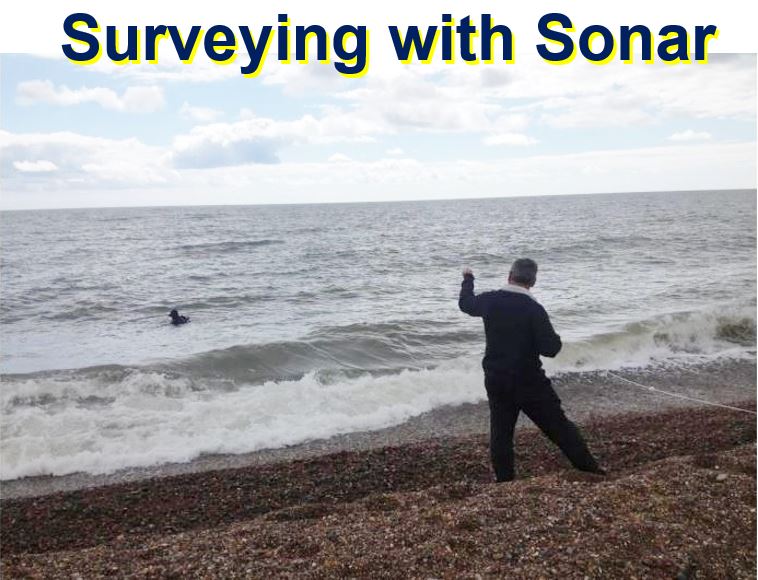 A diver goes into the sea using a tethered safety line and DIDSON-DH sonar. When archaeologists are searching under the sea and everything is virtually pitch black on the sea bed, sonar is the only way to ‘see’ things. (Image: dunwich.co.uk)
The three-year project, funded by Touching the Tide, aims to study and explore how the Suffolk coast has changed. The Touching the Tide project, which is run by the Suffolk Coast & Heaths Area of Outstanding Natural Beauty body, received a £900,000 grant from the National Lottery.
A diver went into the sea and used ultrasound to survey the seabed. The eroding cliffs and marshes were also surveyed.
In an interview with the BBC, Prof. Sear said regarding the project: “It offers a marvellous history of climate change and coastal erosion.”
Town’s decline marked by loss of harbour
Two major storms registered in 1286 and 1326 resulted in the loss of the town’s harbor, which marked its inevitable decline.
Pollen analysis suggests that local residents started giving up on Dunwich after 1338, when another devastating storm silted up the port permanently, and food production plummeted.
The scientists confirmed the sequences of storms recorded in the historical records by analyzing sediment collected from the cliffs.
 Prof. Sear says he and his team are learning a great deal about coastal erosion and the impact of climate change. (Image: University of Southampton)
After dating the old defensive town ditch, the researchers were surprised to find that Dunwich’s origins appear to date back to the Iron Age.
“The Iron Age of the British Isles covers the period from about 800 BC to the Roman invasion of 43 AD, and follows on from the Bronze Age.”
Churches, a toll house and shipwreck found under the sea
The scientists carried out their underwater research using acoustic imaging technology, and have discovered a series of buildings.
Prof. Sear said:
“We use sound to create a video image of the seabed and the reason we do that is because when you dive at Dunwich it’s pitch black.”
“We found the ruins of about four churches and we’ve also found ruins of what we think was a toll house. But we’ve also found shipwrecks for example, and there’s some we’ve found with this Touching the Tide project, which no-one’s known before.”
Just north of the village the team found a shipwreck. The 105-foot (32 metre) ship’s ribs are covered in a thin sheet of copper, which has been dated to after 1750.
Prof. Sear and colleagues, who started researching Dunwich eight years ago (2008), said they do not yet know the ship’s identity and are currently liaising with local museums.
Saxon occupation at Dunwich
The website dunwich.org.uk informs that Prof. Sear and team have revealed clear evidence for Saxon occupation and industry at Dunwich.
According to two project reports that are available online (citations below), movement of sands from the 2013/14 storms have buried much of the archaeology of the sea bed.
Dating of one of the roads and the Town ditch show they were of Saxon or earlier origin.
The Dunwich website writes:
“Dating of a sediment core from the old harbour estuary reveals evidence for Saxon rope making industry. Collectively the evidence supports the view that Dunwich was a substantial Saxon port, prior to its rapid growth following the Norman invasion.”
Citations:
1. “Touching The Tide Project Report Dunwich Marine Archaeology Survey,” Professor David Sear. Department of Geography & Environment, University of Southampton 2015.
2. “Touching The Tide Dunwich Land based Archaeological Survey: 2014-15,” D.A.Sear, R.G.Scaife & C. Langdon. Department of Geography & Environment, University of Southampton 2015.
Video – Dunwich the lost city of East Anglia
Dunwich used to be a prosperous coastal town, which ended up mostly under the sea. What is left today (above sea level) is just a small village.