Not only was Arctic sea ice at a record low on February 25th, it also reached its winter peak too early this year. The peak marks the beginning of the sea ice melt season, the National Snow and Ice Data Center informed on Thursday.
In other words, peak ice levels reached record lows, the amount of ice peaked earlier than normal, and from now on for rest of this year that low amount of ice (probably) starts melting.
Sea ice has been shrinking by about 5% each year over the past ten years.
The US based National Snow and Ice Data Center added (NSIDC), however, that a late-season surge in ice growth remains a possibility, but it believes the melting has started. The Center says it will post a detailed analysis of the 2014-15 winter sea conditions early in April.
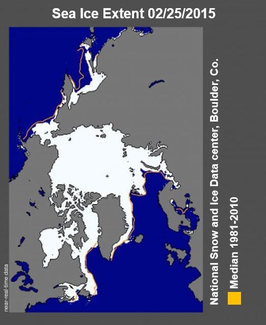
February 25 Arctic sea ice extent was 14.54 million sq km (5.61 million sq m). The orange line shows the 1981 to 2010 median extent for that day. The black cross indicates the geographic North Pole. Sea Ice Index data. (Image: NSIDC)
The ‘likely’ peak reached for the year was 5.61m square miles (14.54 million square kilometers). Ice conditions this winter were below average throughout the Arctic, with the exception of the Davis Strait and Labrador Sea.
This year’s peak is 425,000 square miles (1.10 million square kilometers) less than the 1981 to 2010 average of 6.03 million square miles (15.64 million square kilometers). It is also well below the previous lowest maximum recorded in 2011.
2015’s peak on February 25th occurred 15 days earlier than the 1981 to 2010 average (March 12). The date of the peak has ranged over the last three decades from February 24th in 1996 to April 2nd in 2010.
The NSIDC wrote:
“Because of the variability of ice extent at this time of year, there can be some delay in pinpointing the date of the maximum extent, as was true this year.”
“NSIDC calculates daily ice extent as an average of the previous five days (see the Sea Ice Index documentation for more information), and we also look for a clear downward trend for a number of days.”
While the peak was abnormally low on February 25th, the trend subsequently flattened. This was partly due to recent ice growth in the Bering Sea, partly offsetting the continued ice retreat in the Kara and Barents seas.
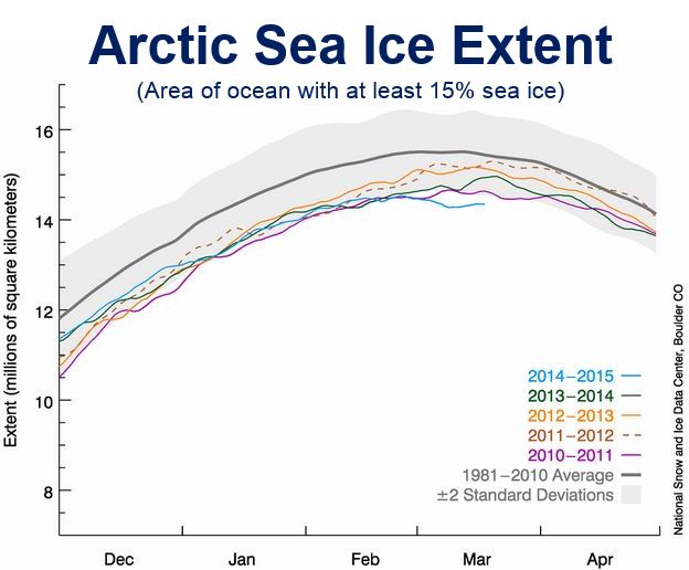
March 18 Arctic sea ice extent, along with daily ice extent data for four previous years. 2014 to 2015 is shown in blue, 2013 to 2014 in green, 2012 to 2013 in orange, 2011 to 2012 in brown, and 2010 to 2011 in purple. The 1981 to 2010 average is in dark gray. The gray area around the average line shows the two standard deviation range of the data.Sea Ice Index data. (Image: NSIDC)
Although periods of increase are still possible over the next two to three weeks “It now appears unlikely that there could be sufficient growth to surpass the extent reached on February 25,” NSIDC wrote.
Weather patterns contributing to record low maximum
During the 2014-15 winter season, sea ice extend grew by 3.83 million square miles (9.91 million square kilometers). This was significantly less ice growth than in 2013-14, which registered record winter growth. The record low maximum is partly due to recent weather patterns.
NSIDC reported:
“February was characterized by an unusual configuration of the jet stream, leading to warm conditions over the Pacific side of the Arctic that maintained low sea ice extent in the Bering Sea and the Sea of Okhotsk.”
“Furthermore, since the last half of February through the middle of March, the Arctic Oscillation was in a strongly positive phase, with index values exceeding 5.0 for several days in the first week of March.”
This has been expressed as a strong Icelandic Low, a semi-permanent of low atmospheric pressure between southern Greenland and Iceland and extending well into the Barents Sea.
The strong Icelandic Low caused a pattern of surface winds of the Kara and Barents seas with an abnormally strong component from the south.
During the first fourteen days of March, temperatures at approximately 3,000 feet altitude in the Arctic were several degrees Celsius above average, reaching 8°C to 10°C (14°F to 18°F) above average in the Barents Sea between Franz Josef Land and Svalbard.
Although the 7-day weather forecasts show continued warmer-than-average temperatures over the eastern Arctic, colder-than-average weather is expected over the Bering Sea and may still result in some new ice formation. “Thus, while the maximum appears to have occurred on February 25, late season ice growth may still occur,” NSIDC wrote.
NASA Video – Arctic Sea ice at record low