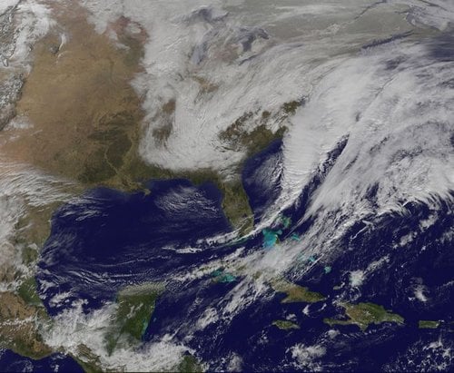
Meteorologists at the National Weather Service have been monitoring a low pressure area that moved from the USA’s Midwest into the Atlantic Ocean and has become a strong nor’easter, bringing blizzard conditions to the northeast of the country.
The system’s path was captured in a NASA movie of NOAA’s GOES-East satellite imagery. (GOES stands for Geostationary Operational Environmental Satellite).
The imagery from the satellite captured from January 24th through 26th has been used to make an animation showing the progression of the developing nor’easter.
On January 24th, clouds associated with a cold front preceding the low pushed off the US East coast. The front was followed by an area of low pressure that moved from the Midwest to the southeast. The low pressure area moved over the Carolinas and made its way into the Atlantic Ocean on January 26th.

NOAA’s GOES-East satellite captured the center of the developing Nor’easter located off North Carolina’s Outer Banks on Jan. 26 in the image from 16:30 UTC (12:30 p.m. EST). (Image Credit: NASA/NOAA Goes Project)
NOAA’s National Weather Service said the low would intensify along the Eastern Seaboard and bring severe blizzard conditions to the northeast of the country on Monday night as well as Tuesday (January 26th & 27th).
The National Weather Service wrote on Monday:
“A storm system off the East Coast will continue to strengthen as it develops into a major nor’easter on Monday. As the storm moves up the coast, it is expected to bring snowfall of 1-3 feet or more to many parts of the Northeast through Tuesday evening, including New York City and Boston.”
“Strong, gusty winds will combine with the snow to create blizzard conditions along and near the coast.”
Winter storm warnings were issued for much of the interior of New England down to the northern Mid-Atlantic, the panhandles of West Virginia and Maryland, and Massachusetts.
Severe weather warnings are also in effect for the southern Appalachians, the Mid-Atlantic, portions of the Ohio Valley, and a narrow area across interior New England.
The Nasa/Goddard Space Flight Center wrote:
“To create the video and imagery, NASA/NOAA’s GOES Project located at NASA’s Goddard Space Flight Center in Greenbelt, Maryland overlays the cloud data from NOAA’s GOES-East satellite on a true-color image of land and ocean created by data from the Moderate Resolution Imaging Spectroradiometer, or MODIS, instrument that flies aboard NASA’s Aqua and Terra satellites. Together, these data create the entire animation of the storm and show its movement.”
Video – Satellite Witnesses Developing U.S. Nor’easter
